using System;
using System.Diagnostics;
using System.Windows.Forms;
using AxMapWinGIS;
using MapWinGIS;
namespace Examples
{
public partial class MapExamples
{
{
string unknown_format = "4326";
string filename = "some_name";
Debug.Print(
"Projection loaded: " + proj.
Name);
string s = "";
double[] arr = new double[5];
for (int i = 0; i < 5; i++)
{
}
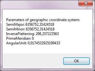
MessageBox.Show("Parameters of geographic coordinate system: " + Environment.NewLine + s);
}
}
}
tkGeogCSParameter
The list of parameters of the geographical coordinate system.
Definition: Enumerations.cs:629
Map component for visualization of vector, raster or grid data.
Definition: AxMap.cs:56
Holds information about coordinate system and projection of the data.
Definition: GeoProjection.cs:98
string Name
Returns the name of the coordinate system.
Definition: GeoProjection.cs:262
bool ImportFromAutoDetect(string proj)
Initializes geoprojection from the input string of arbitrary format.
Definition: GeoProjection.cs:153
bool get_GeogCSParam(tkGeogCSParameter Name, ref double pVal)
Gets specified parameter of the geographic coordinate system.
Definition: GeoProjection.cs:382
bool ImportFromProj4(string proj)
Initializes geoprojection object from proj4 format.
Definition: GeoProjection.cs:183
bool ReadFromFile(string Filename)
Initializes geoprojection from the specified file.
Definition: GeoProjection.cs:282
bool ImportFromEPSG(int projCode)
Initializes geoprojection object from EPSG numeric code.
Definition: GeoProjection.cs:163
string ExportToProj4()
Exports information to the proj4 format.
Definition: GeoProjection.cs:114