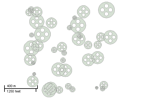
This example demonstrates how to create a shapefile holding circular polygons with holes. Here is a screenshot with the results of the code execution.
using System;
using System.Diagnostics;
using System.Windows.Forms;
using AxMapWinGIS;
using MapWinGIS;
namespace Examples
{
public partial class MapExamples
{
public void PolygonsWithHoles(
AxMap axMap1)
{
bool result = sf.CreateNewWithShapeID(
"",
ShpfileType.SHP_POLYGON);
if (!result)
{
MessageBox.Show(sf.ErrorMsg[sf.LastErrorCode]);
}
else
{
double xMin = 0.0;
double yMin = 0.0;
double xMax = 1000.0;
double yMax = 1000.0;
for (int i = 0; i < 40; i++)
{
double xCenter = xMin + (xMax - xMin) * rnd.NextDouble();
double yCenter = yMin + (yMax - yMin) * rnd.NextDouble();
double radius = 10 + rnd.NextDouble() * 90;
this.AddRing(true, xCenter, yCenter, radius, ref shp);
this.AddRing(false, xCenter + radius / 2.0, yCenter, radius / 4.0, ref shp) ;
this.AddRing(false, xCenter - radius / 2.0, yCenter, radius / 4.0, ref shp);
this.AddRing(false, xCenter, yCenter + radius / 2.0, radius / 4.0, ref shp);
this.AddRing(false, xCenter, yCenter - radius / 2.0, radius / 4.0, ref shp);
for (int j = 0; j < shp.NumParts; j++)
{
Debug.Print("Part is clocwise: " + shp.PartIsClockWise[j]);
}
Debug.Print("Shape is valid: " + shp.IsValid);
if (!shp.IsValid)
Debug.Print("Reason: " + shp.IsValidReason);
sf.EditInsertShape(shp, ref i);
}
sf.SaveAs(@"c:\polygons.shp", null);
}
}
private void AddRing(
bool clockWise,
double x,
double y,
double radius, ref
Shape shp)
{
int partIndex = shp.NumParts;
if (shp.numPoints > 0)
shp.InsertPart(shp.numPoints, ref partIndex);
int count = 0;
for (int j = 0; j < 37; j++)
{
double dx = radius * Math.Cos(j * Math.PI / 18);
double dy = radius * Math.Sin(j * Math.PI / 18);
dy *= clockWise ? -1 : 1;
pnt.x = x + dx;
pnt.y = y + dy;
count = shp.numPoints;
shp.InsertPoint(pnt, ref count);
}
}
}
}
ShpfileType
The type of the shapefile.
Definition: Enumerations.cs:169
tkMapProjection
Commonly used map projections to be set in Form Designer (see AxMap.Projection property).
Definition: Enumerations.cs:1741
Map component for visualization of vector, raster or grid data.
Definition: AxMap.cs:56
A point object represents a point with x, y, Z, and M values. Shapes created by adding point objects ...
Definition: PointClass.cs:38
A shape object represents a geometric shape which can be added to a shapefile which is displayed in t...
Definition: Shape.cs:41
Provides a functionality for accessing and editing ESRI shapefiles.
Definition: Shapefile.cs:72
tkMapProjection Projection
Sets projection of the map. It providers 2 most commonly used coordinate system/projections to be eas...
Definition: AxMap.cs:2709
void ZoomToLayer(int layerHandle)
Zooms the map display to the specified layer.
Definition: AxMap.cs:643
int AddLayer(object Object, bool visible)
Adds a layer to the map.
Definition: AxMap.cs:1342