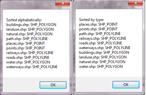
This example demonstrates how to sorts layers by the type of shapefile (first polygons, the polylines and finally points) and alphabetically. Here is a screenshot with the results of the code execution.
using System;
using System.Collections.Generic;
using System.Windows.Forms;
using AxMapWinGIS;
using MapWinGIS;
namespace Examples
{
public partial class MapExamples
{
public void SortLayers(
AxMap axMap1,
string dataPath)
{
if (this.AddLayers(axMap1, dataPath))
{
this.LayersInfo();
this.SortLayersByType();
this.ShowLayerNames("Sorted by type: " + Environment.NewLine);
this.SortAlphabetically();
this.ShowLayerNames("Sorted alphabetically: " + Environment.NewLine);
}
}
private void SortAlphabetically()
{
string[] names =
new string[axMap1.
NumLayers];
{
handles[i] = layerHandle;
}
Array.Sort(names, handles);
try
{
foreach (int handle in handles)
{
}
}
finally
{
}
}
public void SortLayersByType()
{
for (int j = 0; j < 3; j++)
{
List<int> handles = new List<int>();
{
if (sf != null)
{
handles.Add(layerHandle);
handles.Add(layerHandle);
handles.Add(layerHandle);
}
}
try
{
foreach (int handle in handles)
{
}
}
finally
{
}
}
}
private void ShowLayerNames(string description)
{
string message = "";
for (
int i = axMap1.
NumLayers - 1; i >= 0 ; i--)
{
string type = string.Empty;
{
type = (layer as
Shapefile).ShapefileType.ToString();
}
else{
type = "Image";
}
message += name + ": " + type + Environment.NewLine;
}
MessageBox.Show(description + message);
}
public void LayersInfo()
{
int pointCount = 0;
int lineCount = 0;
int polyCount = 0;
int imgCount = 0;
{
if (sf != null)
{
{
pointCount++;
break;
lineCount++;
break;
polyCount++;
break;
}
}
else
{
if (img != null)
{
imgCount++;
}
}
}
string s = string.Format("Layers added to the map:" + Environment.NewLine +
"Point shapefiles: {0}" + Environment.NewLine +
"Polyline shapefiles: {0}" + Environment.NewLine +
"Polygon shapefiles: {0}" + Environment.NewLine +
"Images: {3}", pointCount, lineCount, polyCount, imgCount);
MessageBox.Show(s);
}
}
}
tkLockMode
The lock mode of the map, either locked or not.
Definition: Enumerations.cs:940
ShpfileType
The type of the shapefile.
Definition: Enumerations.cs:169
Map component for visualization of vector, raster or grid data.
Definition: AxMap.cs:56
Represents an raster image of particular format which may be added to the map.
Definition: Image.cs:66
Provides a functionality for accessing and editing ESRI shapefiles.
Definition: Shapefile.cs:72
ShpfileType ShapefileType
Gets the type of the shapefile.
Definition: Shapefile.cs:270
void LockWindow(tkLockMode lockMode)
Locks the window so that any changes will not be displayed until it is unlocked.
Definition: AxMap.cs:524
int get_LayerHandle(int layerPosition)
Gets the handle of the layer at the given position in the map. Returns -1 if there is no layer at the...
Definition: AxMap.cs:1352
int NumLayers
Gets the number of layers loaded in the map.
Definition: AxMap.cs:1422
int get_LayerPosition(int layerHandle)
Gets the position of the specified layer in the map.
Definition: AxMap.cs:1362
object get_GetObject(int layerHandle)
Returns the layer object with the given handle. The object could be a Shapefile, Grid,...
Definition: AxMap.cs:1570
Shapefile get_Shapefile(int layerHandle)
Gets shapefile object associated with the layer.
Definition: AxMap.cs:1546
bool MoveLayerBottom(int initialPosition)
Moves the specified layer below all other layers.
Definition: AxMap.cs:1383
string get_LayerName(int layerHandle)
Gets the name of the specified layer.
Definition: AxMap.cs:1158