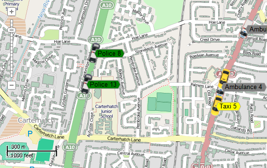
This example demonstrates how to simulate motion of vehicles based on GPS data. Here is a screenshot with the results of the code execution.
using System.Collections.Generic;
using System.Diagnostics;
using AxMapWinGIS;
using MapWinGIS;
using System;
using System.IO;
using System.Windows.Forms;
namespace Examples
{
public partial class MapExamples
{
public void TrackCars(
AxMap axMap1,
string dataPath)
{
if (!InitMap(axMap1, dataPath))
return;
string filename = dataPath + "path.shp";
if (!File.Exists(filename))
{
MessageBox.Show("Path.shp wasn't found: " + dataPath);
return;
}
_carShapefile = CreateCarShapefile(service);
service.StateChanged += ServiceStateChanged;
}
private bool InitMap(
AxMap axMap1,
string dataPath)
{
string filename1 = dataPath + "buildings.shp";
string filename2 = dataPath + "roads.shp";
if (!File.Exists(filename1) || !File.Exists(filename2))
{
MessageBox.Show("Couldn't find the files (buildings.shp, roads.shp): " + dataPath);
return false;
}
sf.
Open(filename1,
null);
sf.
Open(filename2,
null);
return true;
}
private Shapefile CreateCarShapefile(CarService service)
{
sf.DefaultDrawingOptions.AlignPictureByBottom = false;
var ct = sf.Categories.Add("Police");
var opt = ct.DrawingOptions;
opt.Picture = IconManager.GetIcon(CarType.Police);
ct = sf.Categories.Add("Taxi");
opt = ct.DrawingOptions;
opt.Picture = IconManager.GetIcon(CarType.Taxi);
ct = sf.Categories.Add("Ambulance");
opt = ct.DrawingOptions;
opt.Picture = IconManager.GetIcon(CarType.Ambulance);
sf.Labels.FrameVisible = true;
sf.Labels.TextRenderingHint = tkTextRenderingHint.ClearTypeGridFit;
var lb = sf.Labels.AddCategory("Busy");
lb.FrameBackColor = utils.ColorByName(
tkMapColor.Yellow);
lb = sf.Labels.AddCategory("Available");
lb.FrameBackColor = utils.ColorByName(
tkMapColor.Green);
lb = sf.Labels.AddCategory("OutOfService");
lb.FrameBackColor = utils.ColorByName(
tkMapColor.Gray);
Debug.Print("Num categories: " + sf.Labels.NumCategories);
for (int i = 0; i < service.Cars.Count; i++)
{
var car = service.Cars[i];
shp.AddPoint(car.X, car.Y);
sf.EditAddShape(shp);
sf.ShapeCategory[i] = (int) car.CarType;
sf.Labels.AddLabel(car.ToString(), car.X, car.Y);
sf.Labels.Label[i, 0].Category = (int)(car.State);
}
return sf;
}
private void ServiceStateChanged(object sender, EventArgs e)
{
var service = sender as CarService;
if (service == null) return;
for (int i = 0; i < service.Cars.Count; i++)
{
var car = service.Cars[i];
{
_carShapefile.Shape[i].put_XY(0, car.X, car.Y);
_carShapefile.ShapeRotation[i] = car.Direction;
var lbl = _carShapefile.
Labels.Label[i, 0];
lbl.x = car.X + 20;
lbl.y = car.Y;
}
}
}
}
public enum CarState
{
Busy = 0,
Avaiable = 1,
OutOfService = 2
}
public enum CarType
{
Police = 0,
Taxi = 1,
Ambulance = 2
}
public class GeometryHelper
{
public static double GetDirection(double x, double y)
{
if (Math.Abs(y) > 1e-10)
{
double angle = Math.Atan(x / y);
if (y < 0)
{
return Math.PI + angle;
}
if (x >= 0)
{
return angle;
}
return 2.0 * Math.PI + angle;
}
if (x > 0)
{
return Math.PI / 2.0;
}
if (x < 0)
{
return 1.5 * Math.PI;
}
return 0.0;
}
}
public class Car
{
private double _distance;
{
Path = path;
_distance = path.
Length * rnd.NextDouble();
}
#region Properties
public int Id { get; set; }
public double X { get; set; }
public double Y { get; set; }
public double Direction { get; set; }
public double Speed { get; set; }
public CarState State { get; set; }
public CarType CarType { get; set; }
public Shape Path {
get;
set; }
public double MetersPerSecond
{
get { return Speed * 1000 / 3600; }
}
#endregion
#region Methods
public override string ToString()
{
return CarType + " " + Id;
}
public void Move(int interval)
{
double step = MetersPerSecond * interval / 1000;
_distance += step;
if (_distance > Path.Length) _distance = 0;
double dist = 0.0;
double x1, x2, y1, y2;
x1 = x2 = y1 = y2 = 0.0;
for (int i = 1; i < Path.numPoints; i++)
{
Path.
get_XY(i, ref x2, ref y2);
Path.get_XY(i - 1, ref x1, ref y1);
double val = Math.Sqrt(Math.Pow(x2 - x1, 2.0) + Math.Pow(y2 - y1, 2.0));
if (dist + val > _distance)
{
double ratio = (_distance - dist) / val;
x2 = x1 + (x2 - x1) * ratio;
y2 = y1 + (y2 - y1) * ratio;
break;
}
if (dist + val < _distance)
{
dist += val;
}
else
{
break;
}
}
Direction = GeometryHelper.GetDirection(x2 - X, y2 - Y) / Math.PI * 180.0;
X = x2;
Y = y2;
}
#endregion
}
public class IconManager
{
private static Dictionary<CarType, Image> _dict = new Dictionary<CarType, Image>();
private static string _iconPath = Path.GetDirectoryName(Application.ExecutablePath) + @"..\..\..\..\icons\";
static IconManager()
{
foreach (CarType val in Enum.GetValues(typeof(CarType)))
{
string path = IconPathForCarType(val);
if (File.Exists(path))
{
if (img.Open(path))
{
_dict.Add(val, img);
}
}
}
}
private static string IconPathForCarType(CarType type)
{
string path = _iconPath;
switch (type)
{
case CarType.Police:
return path + "police_car.png";
case CarType.Taxi:
return path + "taxi_car.png";
case CarType.Ambulance:
return path + "ambulance_car.png";
}
return string.Empty;
}
public static Image GetIcon(CarType type)
{
return _dict.ContainsKey(type) ? _dict[type] : null;
}
}
public class CarService
{
private const int UPDATE_INTERVAL = 200;
public List<Car> Cars = new List<Car>();
public event EventHandler StateChanged;
private Timer _timer = new Timer();
private void FireStateChanged()
{
var handler = StateChanged;
if (handler != null)
handler(this, new EventArgs());
}
{
if (ext == null)
throw new NullReferenceException();
CreateCars(ext, paths, numCars);
UpdatePositions();
InitTimer();
}
{
Cars.Clear();
for (int i = 0; i < numCars; i++)
{
var path = paths.Shape[0];
double x = ext.
xMin + (ext.
xMax - ext.
xMin) * _random.NextDouble();
double y = ext.
yMin + (ext.
yMax - ext.
yMin) * _random.NextDouble();
var car = new Car(path, _random)
{
Id = i,
X = x,
Y = y,
Speed = 30 + 50 * _random.NextDouble(),
CarType = (CarType)_random.Next(3),
State = (CarState)_random.Next(3),
};
Cars.Add(car);
}
}
private void InitTimer()
{
_timer.Interval = UPDATE_INTERVAL;
_timer.Start();
_timer.Tick += (s, e) => UpdatePositions();
}
private void UpdatePositions()
{
foreach (var car in Cars)
{
car.Move(UPDATE_INTERVAL);
}
FireStateChanged();
}
}
}
tkLabelPositioning
The available positioning of the label relative to the parent shape.
Definition: Enumerations.cs:835
tkRedrawType
Types of map redraw.
Definition: Enumerations.cs:1683
tkCollisionMode
Sets drawing behaviour when overlapping labels and charts are present on map.
Definition: Enumerations.cs:282
tkZoomBehavior
Possible zoom behaviours.
Definition: Enumerations.cs:1768
tkMapColor
A list of named constants for some of the well-known colors.
Definition: Enumerations.cs:951
tkPointSymbolType
The available types of point symbols.
Definition: Enumerations.cs:1143
ShpfileType
The type of the shapefile.
Definition: Enumerations.cs:169
tkFileOpenStrategy
Possible open strategies for datasources.
Definition: Enumerations.cs:1799
tkMapProjection
Commonly used map projections to be set in Form Designer (see AxMap.Projection property).
Definition: Enumerations.cs:1741
Map component for visualization of vector, raster or grid data.
Definition: AxMap.cs:56
void Redraw2(tkRedrawType redrawType)
Performs specific type of map redraw.
Definition: AxMap.cs:370
Represents a rectangle on the map.
Definition: Extents.cs:49
double xMax
The maximum x bound for the extents object.
Definition: Extents.cs:121
double yMax
The maximum y bound for the extents object.
Definition: Extents.cs:137
double xMin
Gets the minimum x bound for the extents object.
Definition: Extents.cs:129
double yMin
Gets the minimum y bound for the extents object
Definition: Extents.cs:145
string ExportToWKT()
Exports information to the WKT format.
Definition: GeoProjection.cs:123
Represents an raster image of particular format which may be added to the map.
Definition: Image.cs:66
A shape object represents a geometric shape which can be added to a shapefile which is displayed in t...
Definition: Shape.cs:41
bool get_XY(int pointIndex, ref double x, ref double y)
Gets the coordinates of the specified point.
Definition: Shape.cs:639
double Length
Calculates the length of polyline shape.
Definition: Shape.cs:446
Provides a functionality for accessing and editing ESRI shapefiles.
Definition: Shapefile.cs:72
Labels Labels
Gets or sets the instance of the Labels class associated with the shapefile.
Definition: Shapefile.cs:184
int NumShapes
Gets the number of shapes in the shapefile.
Definition: Shapefile.cs:254
tkCollisionMode CollisionMode
Gets or sets collision mode for point symbols for point and multi-point shapefiles.
Definition: Shapefile.cs:97
A utils object provides access to a set of utility functions to perform a variety of tasks on other o...
Definition: Utils.cs:20
int Generate(string Expression, tkLabelPositioning Method, bool LargestPartOnly)
Generates labels for each shape of the parent shapefile.
Definition: Labels.cs:490
tkMapProjection Projection
Sets projection of the map. It providers 2 most commonly used coordinate system/projections to be eas...
Definition: AxMap.cs:2709
GeoProjection GeoProjection
Gets or sets projection for map.
Definition: AxMap.cs:2719
bool GrabProjectionFromData
Gets or sets a value indicating whether projection for will be taken from the first datasource added ...
Definition: AxMap.cs:2701
Extents Extents
Gets or sets the extents of the map using an Extents object.
Definition: AxMap.cs:2426
void ZoomToMaxExtents()
Zooms the map to the maximum extents of all loaded layers.
Definition: AxMap.cs:652
void ZoomToLayer(int layerHandle)
Zooms the map display to the specified layer.
Definition: AxMap.cs:643
bool DisableWaitCursor
Gets or sets a boolean value which indicates whether a wait cursor will be displayed on map redraw.
Definition: AxMap.cs:533
tkZoomBehavior ZoomBehavior
Gets or sets zoom behaviour for the map control.
Definition: AxMap.cs:465
int AddLayer(object Object, bool visible)
Adds a layer to the map.
Definition: AxMap.cs:1342
Shapefile get_Shapefile(int layerHandle)
Gets shapefile object associated with the layer.
Definition: AxMap.cs:1546
int AddLayerFromFilename(string filename, tkFileOpenStrategy openStrategy, bool visible)
Adds layer from the specified datasource.
Definition: AxMap.cs:1328
bool Volatile
Gets or sets a value indicating whether shapefile can be redrawn without redrawing other layer on the...
Definition: Shapefile.cs:923
bool Open(string shapefileName, ICallback cBack)
Opens shapefile from the disk.
Definition: Shapefile.cs:1430